TOWARDS AN INTELLIGENT GEOSPATIAL DIGITAL TWIN
In collaboration with Changjie Chen, Shangde Gao, Jeffrey Carney, and Jorg Peters
Introduction: Geospatial Digital Twins
Urban Digital Twins (UDTs) have emerged as a new framework for planning and studying cities based on data, with real-time monitoring, predictive modeling, and participatory interfaces.
UDTs are defined as dynamic digital representations of city systems with a back-and-forth flow of data between city infrastructure and computational models. Recently, scholars have critiqued UDTs for obscuring the local contexts of data production and reproducing social and political inequalities while seemingly being neutral technology.
Pilot UDT projects demonstrate applications in energy, mobility, and participatory planning, but also reveal limitations: restricted public access, reductive modeling of citizen behavior, and dependence on a single company’s system. These systems have biases that shape how we see urban processes. We therefore argue for a new methodological framework—termed Geospatial Digital Twins (GDTs)—that reclaims these models as adaptive, participatory systems integrating local knowledge, real-time monitoring, predictive modeling, and democratic engagement.
From Cyber-Physical Systems to Social-Cyber-Physical Systems
A GDT incorporates technological advancements that aim at abstracting the physical world and connects digital models, real places, and their context. Existing computational urban models address specific dimensions of urban complexity but remain confined to distinct methodological scopes. The proposed GDT framework provides a unifying structure where computational urban models operate as parts of GDTs.
A GDT promises to transform how we design, model, build, simulate, and manage, providing a platform to join quantitative and qualitative data and models for testing scenarios and making informed decisions. There is a need for a unified framework that combines various modeling techniques within a single standardized environment. DTs in the literature exist on a continuum from simple static models to fully dynamic, intelligent, and interconnected systems.
Suppose we concentrate on the data flow in a DT. In that case, it can be described through a range that progresses through four stages: a Digital Model (DM), which is a static digital representation of a physical object or environment; a Digital Shadow (DS), where the model receives unidirectional data from the physical system but cannot influence or interact with it; a Digital Twin, which establishes a two-directional connection between physical and digital systems; and finally, an Intelligent or Connected Digital Twin, where the system integrates AI, predictive analytics, and interconnected networks to enable autonomous decision-making, optimization, and coordination across domains. In Table 1, we have summarized the contributions that define different DT categories.
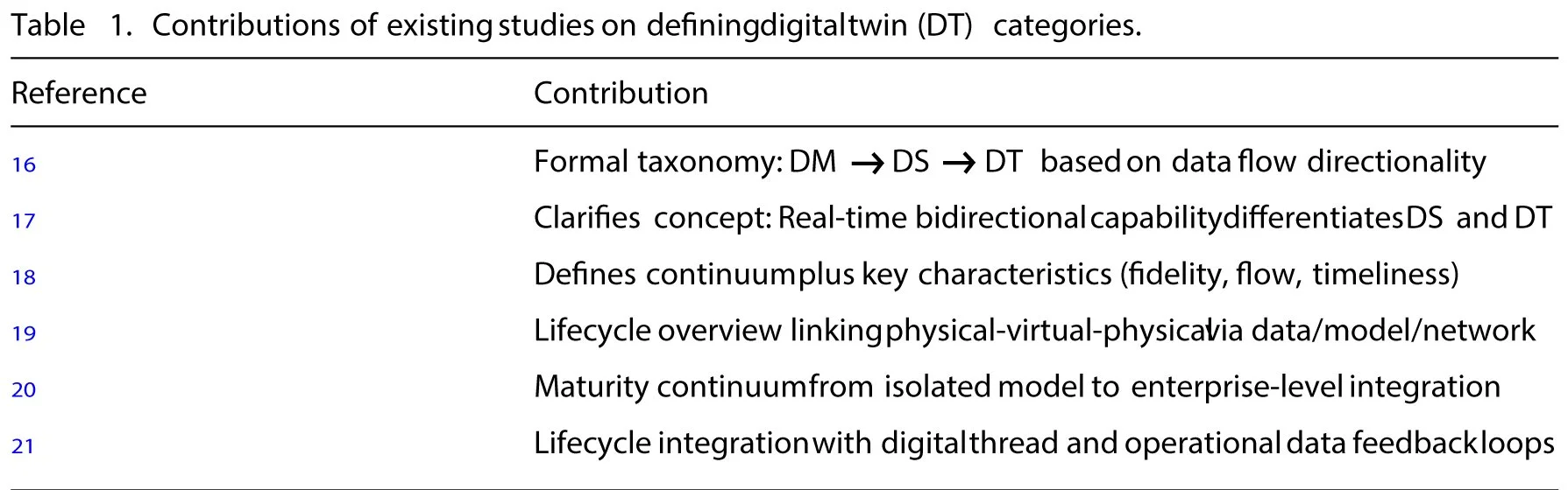
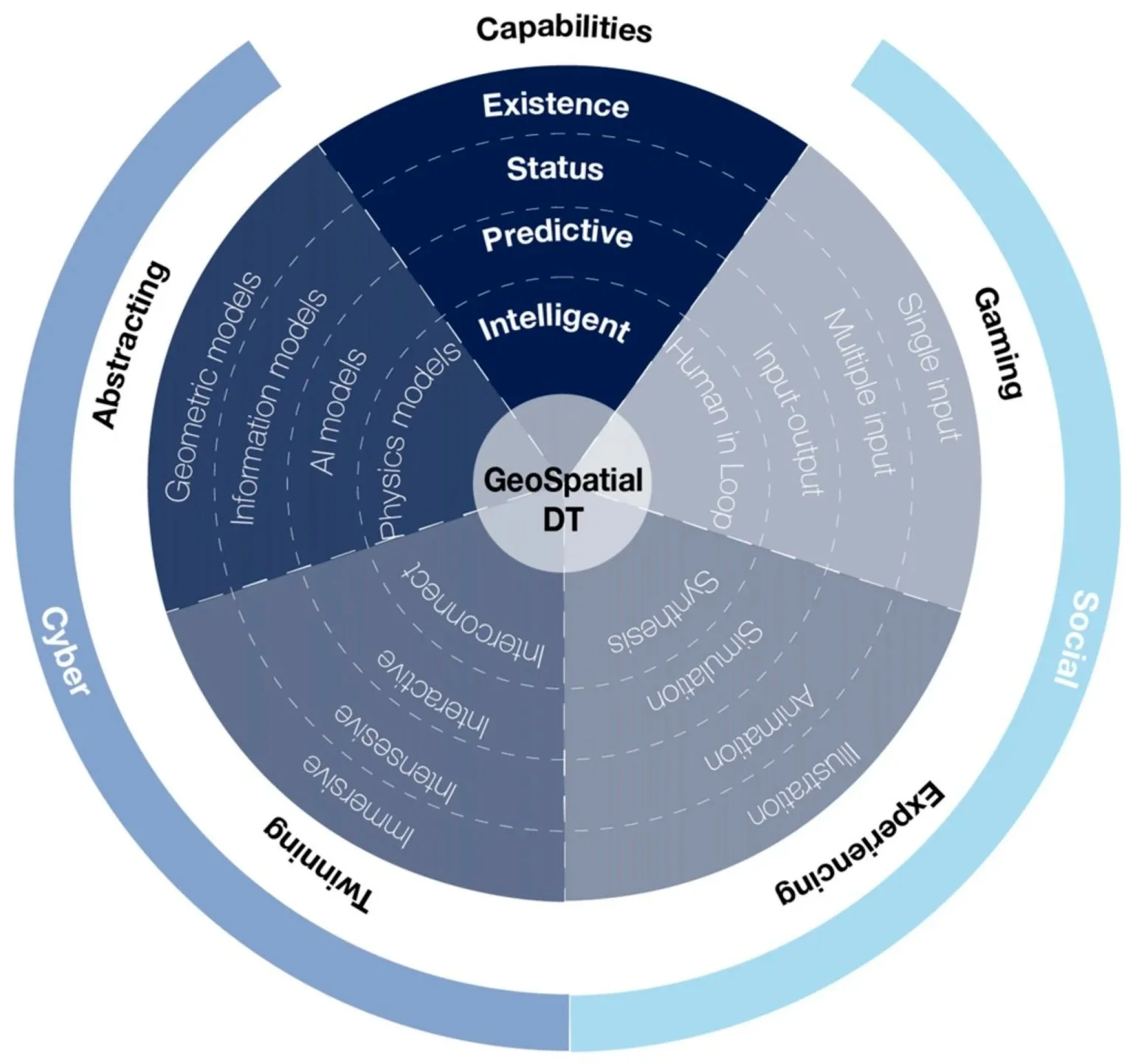
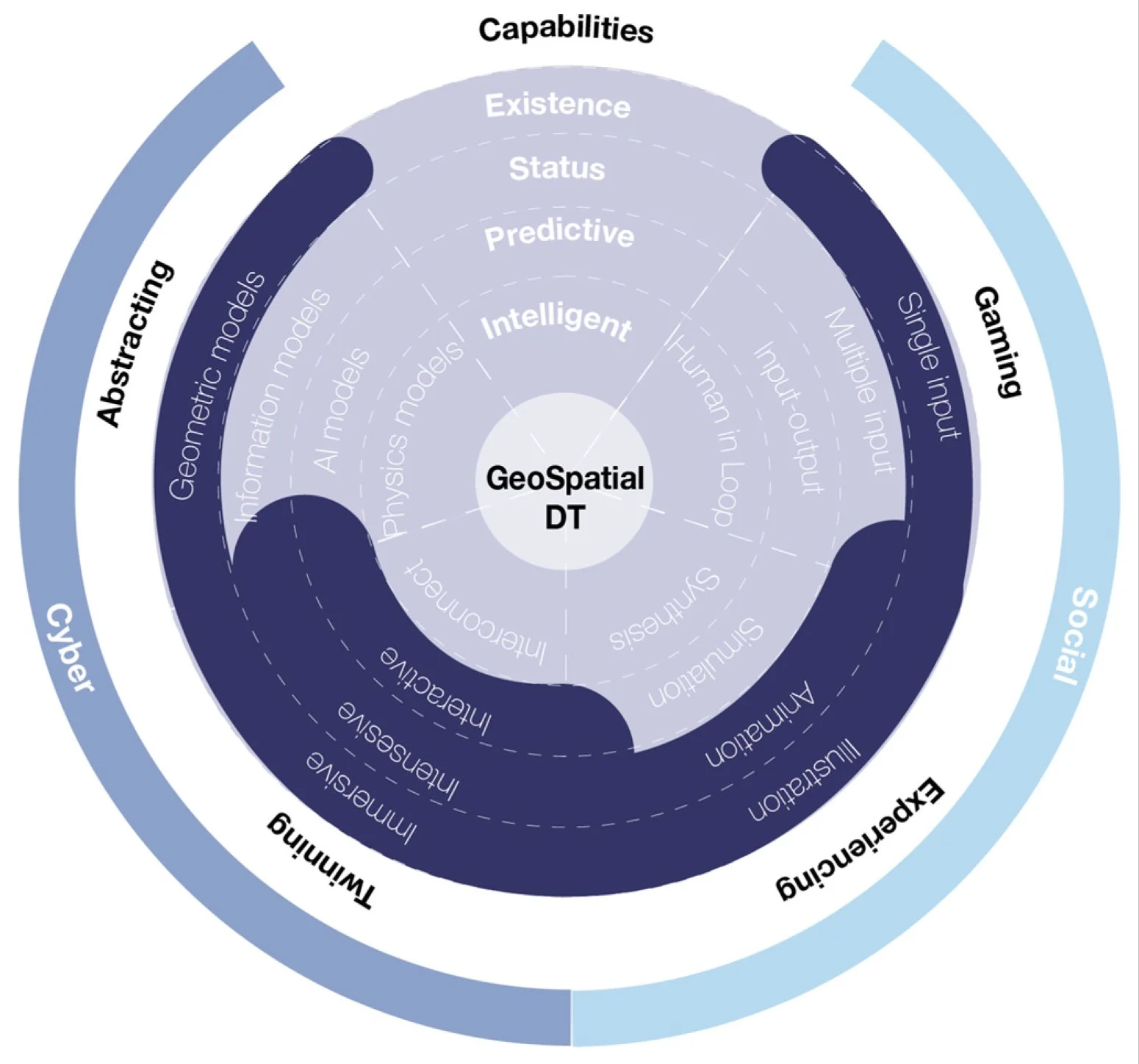
In this article, we introduce a new theoretical framework that complements the cyber-physical system perspective by highlighting the importance of social factors in developing a social-cyber-physical GDT. The “social” component is essential, as it provides a new way to model built-environment challenges that complements the cyber one. With a similar motivation, we integrate the following four categories to create a new DT continuum (Figure 1):
• Existence GDT focuses on pipelines to generate geometric environments and create immersive virtual replicas.
• Status GDT sets up a bi-directional data connection for infrastructure, social, and political assets.
• Predictive GDT implements prediction models trained on historical data to identify anomalies in real-time data with a human-centered AI approach.
• Intelligent GDT continuously learns from new data, refines its predictive models, and recommends changes to the real-world asset while keeping humans involved in decision-making.
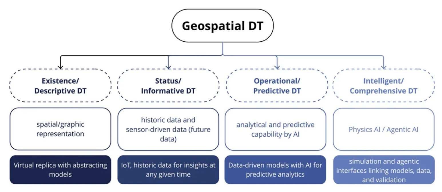
Figure 1. Digital Twin continuums.
The Theoretical, Technical, and Application Framework for Geospatial Digital Twins
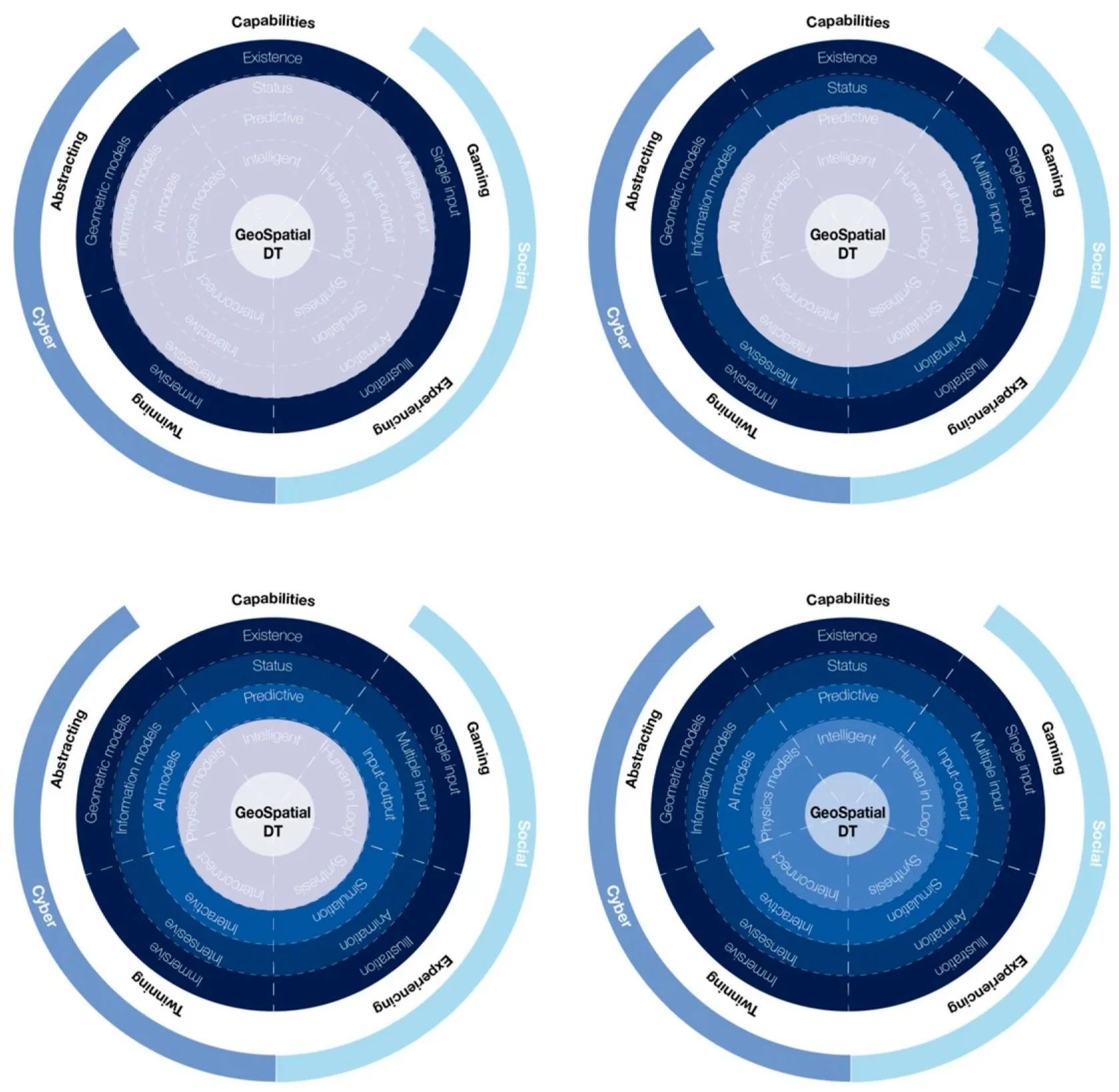
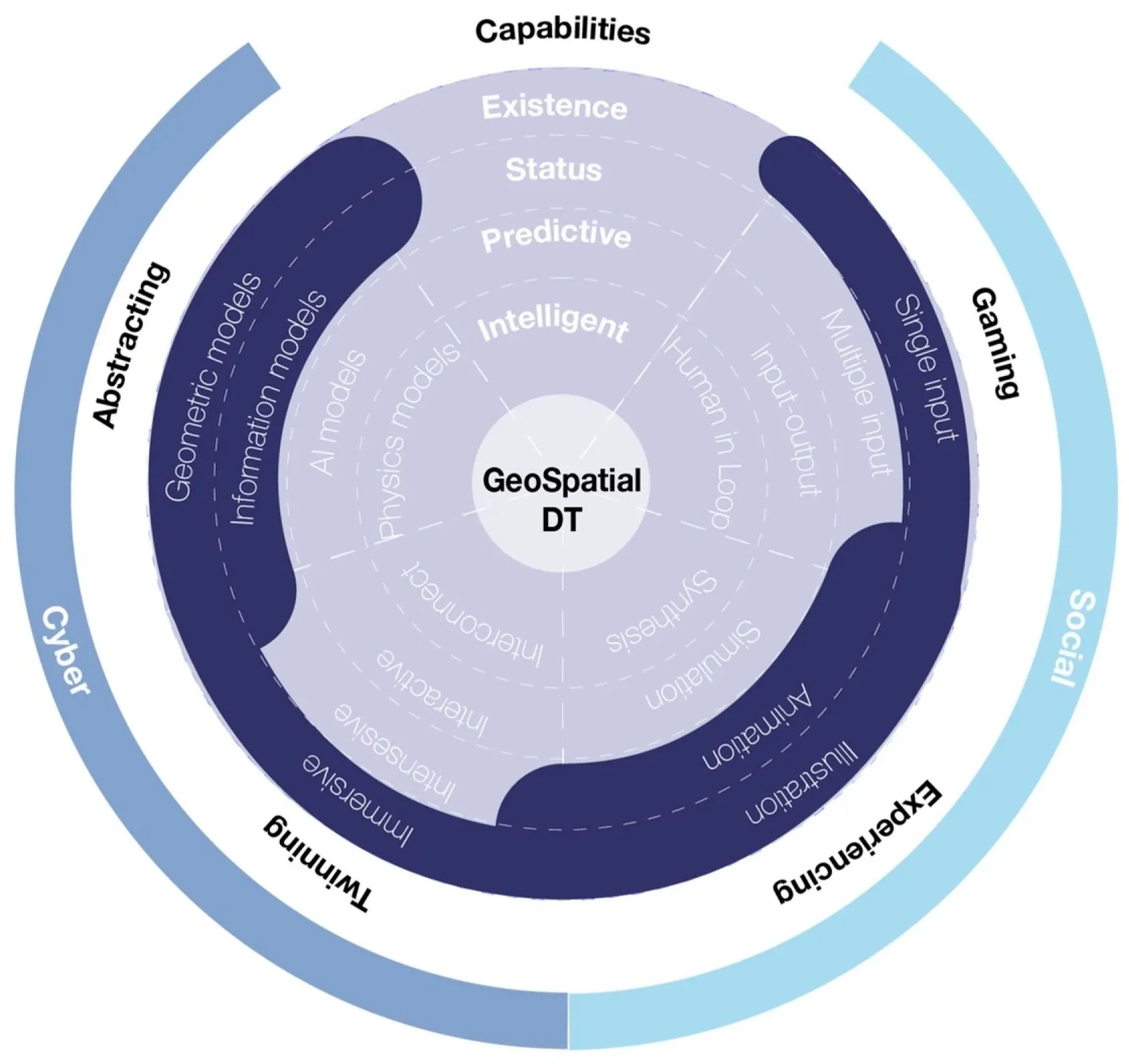
To explore the development and implementation of GDTs, we propose a framework that integrates theoretical concepts and technical advancements with practical applications (Figure 2). The theoretical framework describes a series of socio-cyber-physical developments corresponding to each stage of GDTs, helping distinguish them from regular DTs. The application framework provides examples at two scales—neighborhood and city—that showcase the social relevance of a GDT.
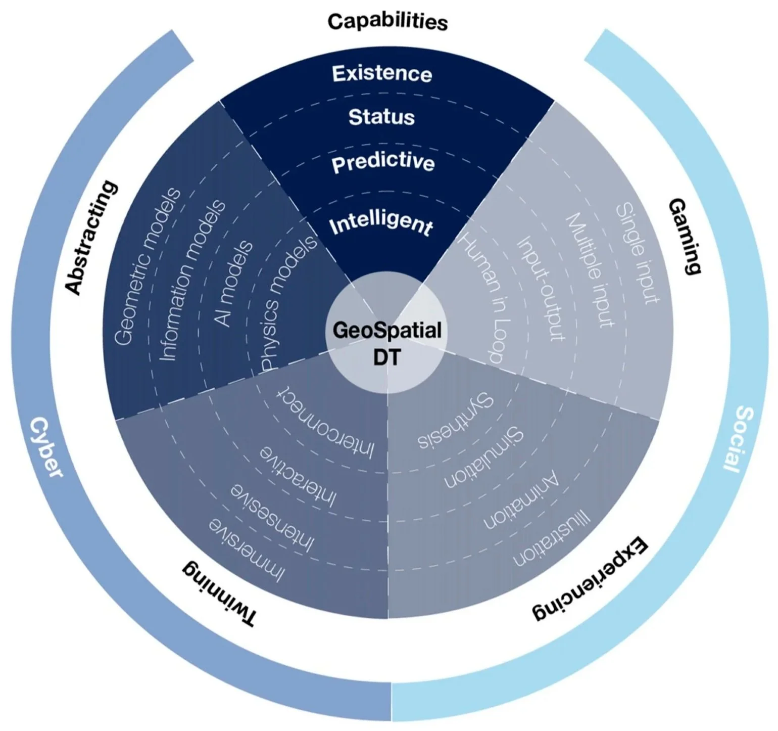
Figure 2. Architecture of Geospatial Digital Twin with intertwined continuums of Abstracting, Twinning, Experiencing, and Gaming.
Theoretical Framework: From Capabilities to Circular Correspondence of Interoperable Capacities
GDTs leverage technologies from DTs and Smart Cities and propose a framework that weighs both cyber and social developments equally (Figure 2). Our framework emphasizes that digital technologies are deeply entangled with social, cultural, and political contexts. In GDTs, cyber and social developments advance in unison to enrich the system’s representation, functionality, and human engagement.
In the cyber implementation, the abstracting range spans from geometric and information models to machine learning and physics-based models. Through immersion, intensity, interactivity, and digital compatibility, twinning provides increasingly integrated, responsive, and networked experiences.
In social implementation, the spectrum of experience defines how knowledge is conveyed and produced: starting with drawings, advancing through animation and simulation, and culminating in synthesis, where insights and design possibilities emerge. The range of gaming depends on engagement, beginning with single-modality input (e.g., textual or numeric), progressing to multimodal input (voice, gesture, sensor data), advancing to multimodal input–output systems (VR/AR), and culminating in human-in-the-loop systems where users actively shape and adapt models. The two ranges are connected because more experiential information leads to a more meaningful gaming experience. GDTs are a multi-layered ecosystem that evolves through social-cyber-physical integration, immersive virtuality, and human-centered co-production (Figure 2).
In practice, the framework (Figure 2) guides implementation, where each quadrant represents a spectrum with more advanced capabilities closer to the center. Practitioners can strategically emphasize specific quadrants based on project needs.
The GDT framework's contribution lies in structuring and integrating established technologies across digital and social areas to create participatory infrastructures for urban decision-making. It prioritizes local knowledge, equity, and democratic engagement.
Abstracting
To implement GDTs, complex systems, algorithms, and models must be developed to facilitate abstracting the physical world and creating virtual approximations. This process starts with:
• Geometric Models: These are produced by hand modeling, photogrammetry, or procedural modeling. AI models can reconstruct a 3D environment from image data for continuous updating.
• Information Models: Examples of information models include BIM and Geographic Information Systems (GIS). Integrating environmental, infrastructure, and citizen information models enables seamless transitions across multiple scales.
• Machine Learning Models: They support decision-making in GDTs by enhancing the functionality and adaptability of these environments through data-driven predictive modeling to classify, predict, and generate based on historical data.
• Physics or Spatial Models and Translation Pipelines: Spatial or Physics AI refers to combining AI with data about spaces, allowing systems to perceive, understand, and interact with the physical world through a geographic or 3D perspective. It makes experiences more intuitive and interactive.
Twinning
Twinning refers to technologies that couple physical and virtual environments and turn static models into dynamic, adaptable spaces. Instead of simply storing information, twinning creates virtual replicas to enhance human experience. Here are the four interconnected capabilities:
• Immersive Environments: Emphasize clarity, depth, and contextual awareness, allowing stakeholders to grasp relationships in space, dependencies among systems, and the implications of potential interventions.
• Intensive Environments: GDTs provide diverse perspectives, integrating multiple domains of knowledge and allowing both high-level overviews and fine-grained details to coexist within a single system.
• Interactive Environments: Interactivity transforms GDTs into experimental platforms, enabling iterative testing of “what-if” scenarios and supporting adaptive planning processes.
• Interconnective Environments: Involve creating accessible, stakeholder-facing interfaces that enable experts and non-experts alike to engage in collaborative scenario testing, participatory design, and consensus building.
Experiencing
It describes a sequence used to enhance stakeholders’ experience when interacting with GDTs by transforming data into perception (illustration), perception into process (animation), process into understanding (simulation), and finally, understanding into creation (synthesis).
• Illustration: These tools make data, systems, or ideas visible.
• Animation: Extends illustration by representing the evolution of states over time, letting us see motion and even understand stories.
• Simulation: Advances further by embedding causality through rules, relationships, and behavioral logics. Simulation allows systems to be explored under varying conditions to see how change occurs, why dynamics shift, and what alternative futures might emerge.
• Synthesis: Integrates all three modes into an act of generation. By fusing illustration, animation, and causality simulation, synthesis enables the creation of new forms, scenarios, or knowledge to inform design and decisions.
Gaming
Gaming technologies are designed as immersive, playable worlds and enable influence over GDTs. This spectrum focuses on making the feedback between human and cyber worlds into fully integrated systems where humans have a hand in the digital processes. Advancements in the accuracy of the models to align with human senses and perception reflect game development principles of world-building, rule creation, and user immersion.
• Single-Modality Input: At the most basic level, user feedback is provided through textual commands, numeric values, or predefined forms. This stage ensures initial accessibility but restricts the system’s range of expression and adaptability.
• Multimodal Input: Feedback expands by incorporating multiple input channels such as voice, gesture, and data from sensors. It enriches the system’s responsiveness and aligns feedback with diverse contexts and preferences.
• Multimodal Input–Output: At this stage, GDTs evolve into interactive environments where feedback is not only collected but also immediately represented back to users, fostering iterative learning and adjustment.
• Human-in-the-Loop: The most advanced stage embeds human judgment directly within decision-making processes. Here, GDTs are not autonomous systems but collaborative partners, continuously shaped by human oversight, contextual knowledge, and ethical considerations. Feedback that keeps humans involved in digital processes ensures that models remain adaptable, accountable, and sensitive to social realities.
To conceptualize the evolving capacities of GDTs, Figure 3 illustrates the previously introduced framework, where placement closer to the center represents a greater accumulation of capabilities across the four spectrums, moving from Existence GDT to Status GDT, Predictive GDT, and Intelligent GDT.

Figure 3. Geospatial Digital Twin (GDT) frameworks that emphasize the four continuums with different levels, achieving Existence GDT, Status GDT, Predictive GDT, and Intelligent GDT.
Geospatial Digital Twin Framework Strategy
The GDT framework assumes responsible development and use. This section provides strategies aimed at ensuring transparency in system decision-making, describing recommendations for data ethics, algorithm bias, transparency, and GDT usage.
• Strategy for Data Ethics: Responsible handling of urban data is the foundational design principle of GDTs and aims to ensure data justice, for example, fairness in how individuals and local communities are made visible through digital data processes.
Data for GDTs can be drawn from publicly available state and country databases, such as street-view imagery; information about property owners or human activities is not collected unless necessary.
The scope, level of detail, and accessibility of data are adjusted to project-specific needs while protecting against disproportionate visibility or exclusion of vulnerable populations.
• Strategy for Algorithm Bias: GDTs are developed with explicit attention to algorithmic fairness. To achieve this, we recommend establishing model de-biasing tools to improve generalizability and equitable predictive performance.
• Strategy for Governance Transparency: To legitimize digital decision-making systems like GDTs, people must know how they work, what data they use, and how they reach their conclusions. Since GDTs can influence public policies, there must be ways for experts and the public to review and hold the systems accountable. To support this, the GDT framework keeps humans involved in the decision process. People can examine the system’s recommendations, challenge them, or choose not to follow them before decisions are made. The Experiencing Continuum’s illustration explains the system’s data, assumptions, and reasoning in ways that both expert and non-expert users can understand. The modular system is flexible enough to adapt to different communities’ specific needs.
• Strategy for GDT Usage: We propose a flexible structure that provides a project-based approach by combining abstracting, twinning, experiencing, and gaming. Specific applications can be emphasized or deemphasized to adapt to different contexts and needs. To demonstrate the framework’s feasibility and flexibility, the sections “Geospatial Digital Twin Examples at the Neighborhood Scale: Campustwin” and “Geospatial Digital Twin Example at the City Scale: JaxTwin” present two implementations of GDTs at two scales: a neighborhood with Campustwin and a city with JaxTwin.
These case studies serve as proof-of-concept demonstrations illustrating how the framework’s spectrums can be configured for different project contexts, rather than comparing them to existing approaches. Validating the system with numbers remains an important direction for future work.
Geospatial Digital Twin Examples at the Neighborhood Scale: Campustwin
To illustrate how the GDT framework works both socially and technologically, this section presents the project Campustwin, in which specific capabilities along each spectrum (as highlighted in Figure 4) are selected to develop a GDT at a neighborhood scale.
First, with cyber abstraction, we highlight an information model that classifies regions in a more specific and flexible way. Second, we showcase twinning through a machine learning platform that generates 3D meshes from images to automatically create immersive environments of any city. On the social side, the experiencing spectrum is exemplified through flood animations that help humans understand changing conditions. In the gaming continuum, an interface is introduced that captures localized knowledge about perceived risk on campuses with a single variable input. Together, these examples illustrate how technological and social implementations converge to build adaptive, participatory, and context-aware Digital Twins.
Figure 4. Geospatial Digital Twin framework customized for the Campustwin project.
Cyber – Abstracting: Three-Dimensional Geometric Modelling
The Campustwin project showcases how to create 3D city models for GDTs by developing a framework to generate geometric models using a combination of modelling techniques. While geometric accuracy is essential, it is not sufficient: compatibility, expandability with modules, and adaptability based on real-time data are equally important (Figure 5). In the twinning spectrum of Campustwin, the qualities and modeling strategies that make 3D models suitable for GDTs were examined. Future directions for integrating traditional and new methods into dependable GDTs ready for decision-making were outlined.
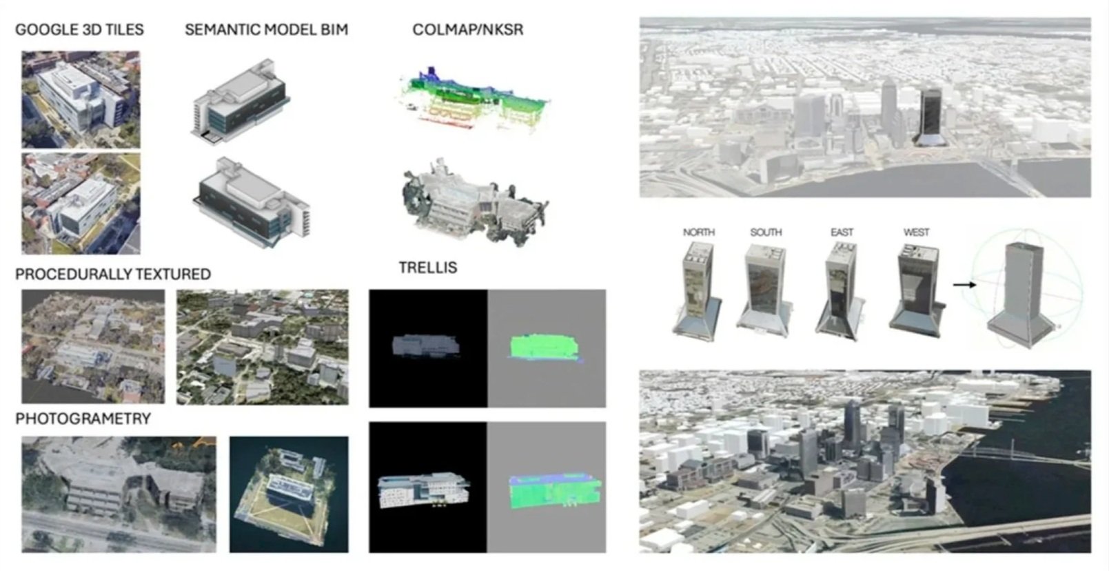
Figure 5. List of the principal approaches to creating 3D city models, including footprint extrusion, photogrammetry, LiDAR-based reconstruction, and semantic or procedural modeling, as well as emerging generative AI methods that reconstruct buildings directly from images. Each approach is situated in terms of its input data, achievable levels of detail (LoD), and trade-offs between automation, realism, accuracy, and scalability
Cyber – Twinning: Intensity for Data-Driven Regionalization
Technology contributes to GDT data frameworks that can extend beyond rigid administrative units. To address the limitations of conventional planning boundaries, such as postal codes, the Campustwin project introduced a regionalization framework, aligned with data intensity on the Twinning spectrum, that applies machine learning to generate planning units that reflect the demands of disaster preparedness and adaptation.
The framework was applied in Jacksonville, Florida, for flood risk adaptation, where it helped identify priority areas, optimize resource distribution, and refine regional boundaries (Figure 6). By embedding user feedback into the computational process, this approach improves participation in rigorous data technologies, advancing the capabilities of the Digital Twin architecture.
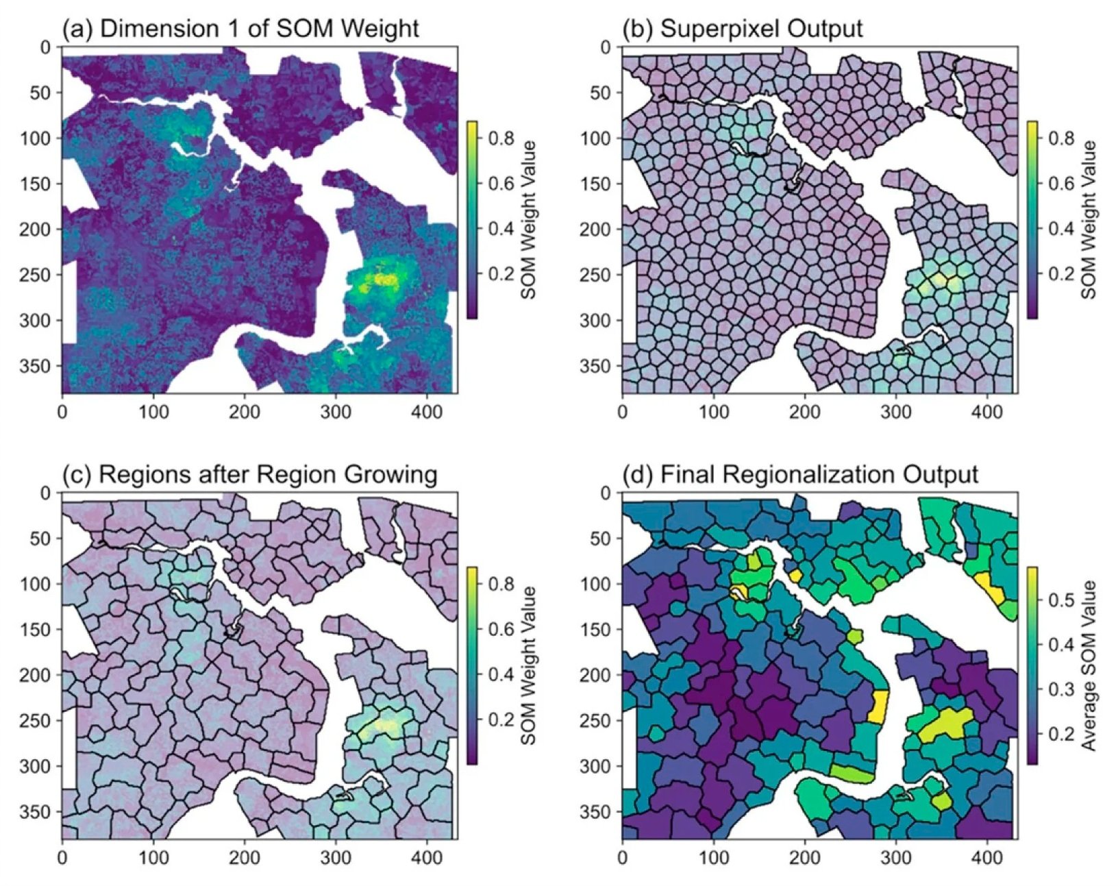
Figure 6. Stepwise outputs of the regionalization process, including a Self-Organizing Map weight map (e.g., Dimension 1), spatial partitioning output (e.g., superpixels), region-growing refinement, and final regionalization result
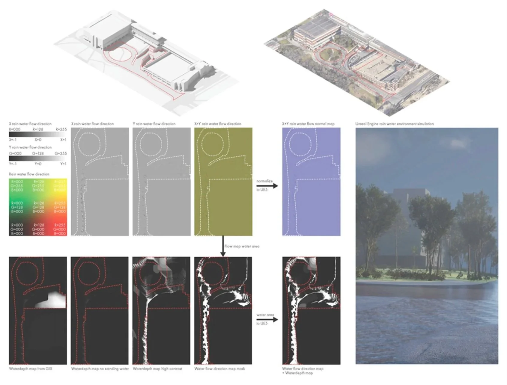
Social – Experiencing: Animation for Flood Visualization
Animation introduces time to enable stakeholders to see the process unfold. Campustwin developed a flood simulation pipeline that illustrates this stage of the Experience spectrum by turning datasets of water dynamics into flood narratives that change over time. We built a pipeline that transforms simulator data, such as water depth, into animated surface behaviors (Figure 7). Experiencing the flooding through animation helps stakeholders understand the urgency and duration of the risk.
Stakeholders can also control playback or jump to specific points, letting them interact and make decisions with a story that is being told visually. In doing so, it promotes GDTs as a means of public communication, resilience planning, and participatory design.
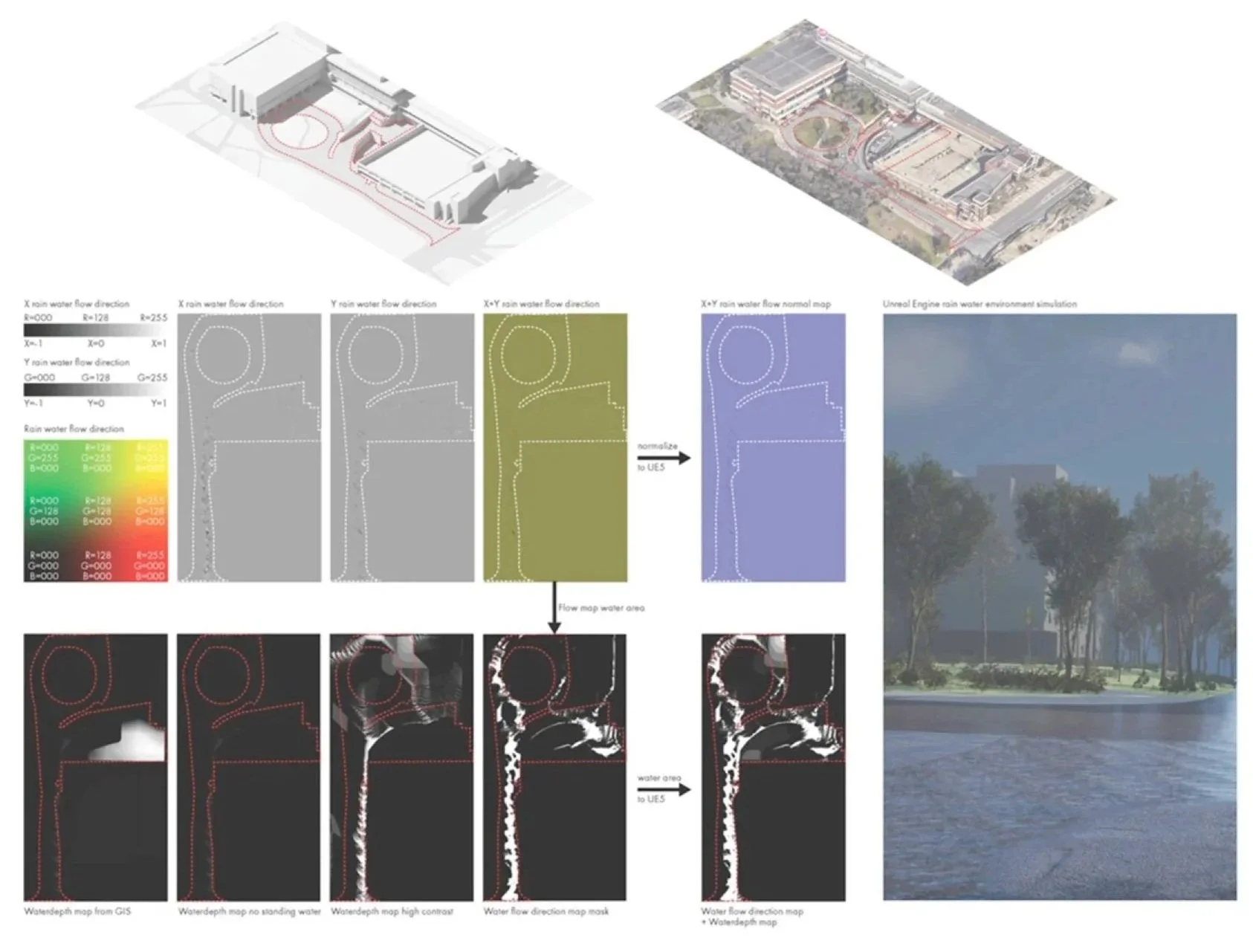
Figure 7. Procedure of flood simulation in the Campustwin project, including determining the simulation boundary, flood flow simulation, and visualization through an immersive virtual environment.
Social – Gaming: Single-Modality Input in Campus Risk Perception
For Campustwin, a workshop was conducted with a diverse group of university students. Students and faculty provided written answers to questions like: ‘Which objects might be at risk during a hurricane?’ and ‘Do you feel safe when walking here?’ These responses were recorded and tagged by location, directly connecting perceptions to features in space. Surveys and focus group discussions were used to triangulate qualitative data on flood risk perceptions. A web-based interface (Figure 8) was employed to display aerial and street-level imagery. Over 205 contributions were collected and analyzed using qualitative techniques, such as word frequency analysis. Results revealed that most participants felt unsafe walking in certain areas during potential flooding events.
By integrating perceptions into the same digital space as models, planners can directly compare modeled risks with locally perceived vulnerabilities and prioritize targeted pre-disaster preparedness strategies. As feedback systems evolve to accommodate human feedback and many different types of data inputs, such early efforts lay essential groundwork for integrating social realities into cyber infrastructures.
The Campustwin example suggests how the theoretical framework of parallel cyber and social continuums can be advanced through concrete implementations.
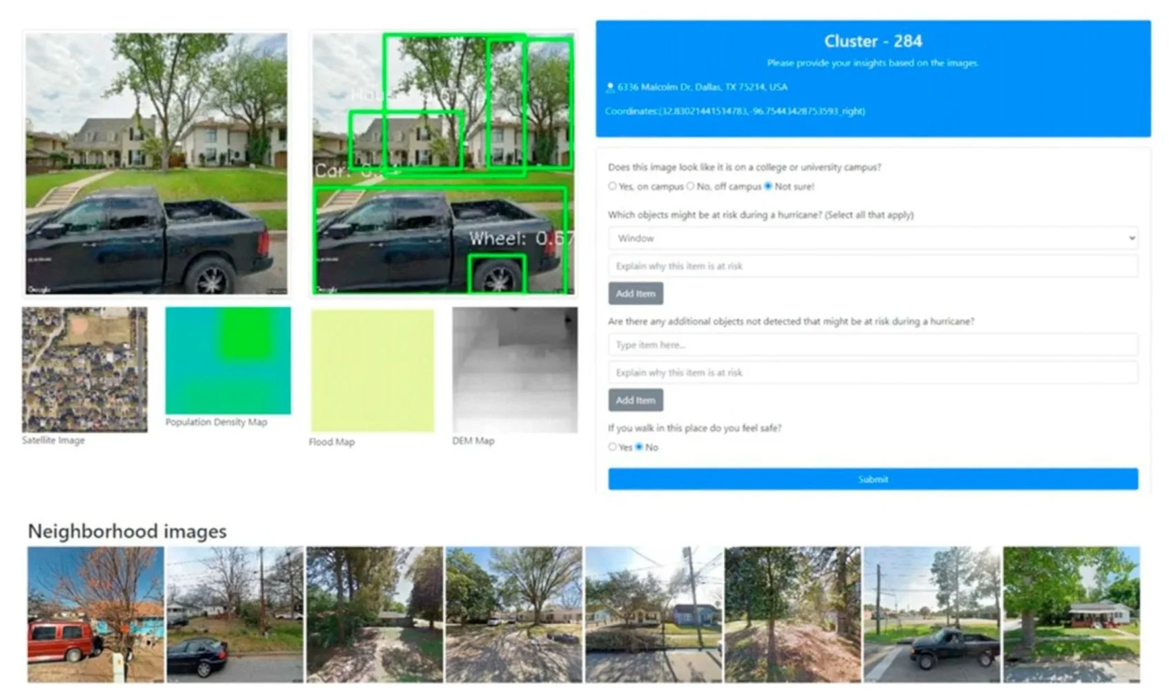
Figure 8. Labeling interface, showcase, and example of a one-input platform for Campustwin.
Geospatial Digital Twin Example at the City Scale: JaxTwin
The following section discusses JaxTwin, a prototype GDT developed for Jacksonville, Florida (Figure 9). It aims to facilitate participation in planning and climate resilience in cities. JaxTwin demonstrates how real-world GDTs can be built with selective components of the framework.
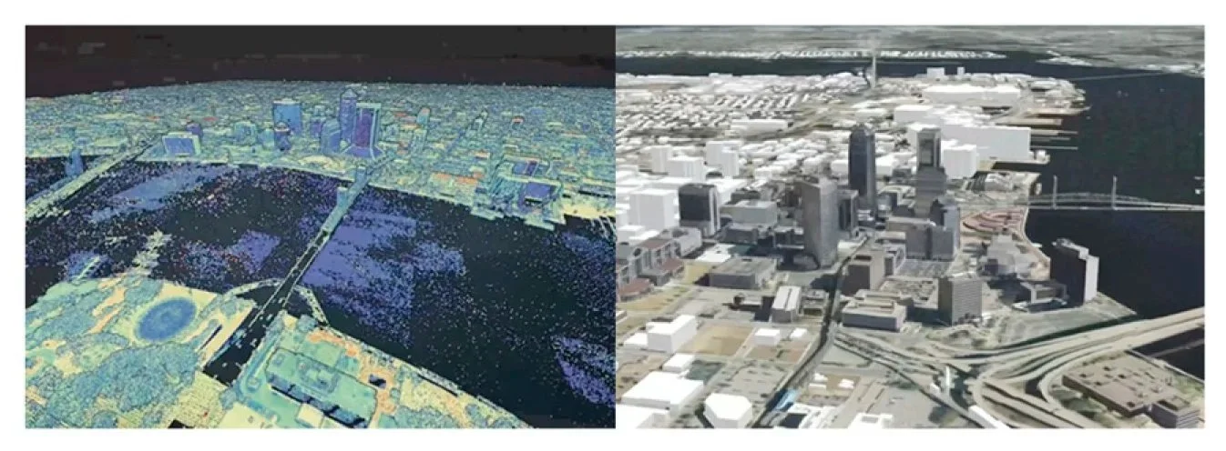
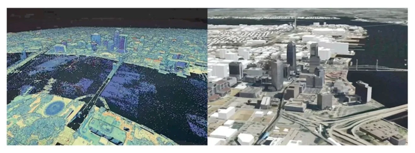
Cyber – Abstracting: From Point Cloud to 3D Objects
JaxTwin employs a GIS workflow to create a contextual model for understanding the built environment. The prototype incorporates LiDAR-scanned 3D models of more than 32,000 buildings that cover the city core and the “Eastside” neighborhoods of the city (Figure 10). JaxTwin extends the “abstracting” spectrum by integrating geographic data about health, the environment, and demographics to make informative models that show social and economic variables.
Cyber – Twinning: Interactivity in a Web-Based Platform
Coupling the geographic data with real-world application scenarios aims to ensure that a digital twin remains relevant to user needs and operational workflows, rather than being just a digital replica of real environments. Conceptually, twinning involves aligning the structure of the data, models for analysis, and tools for visualization with clear use cases. This alignment can be achieved with human–computer interaction (HCI). By analyzing the behavior, decisions, and tasks required of users, HCI informs the design of interfaces and ways of interacting to better engage with complex geographic information.
The GDT system’s user interface (UI) and user experience (UX) were shaped by the workflows of planners, stakeholders, and decision-makers, making it possible for the platform to support their planning and analysis (Figure 11). These features highlight the ongoing spectrum of immersion, interactivity, and connectivity, making JaxTwin a platform where technical modeling seamlessly integrates with straightforward, stakeholder-centered design.
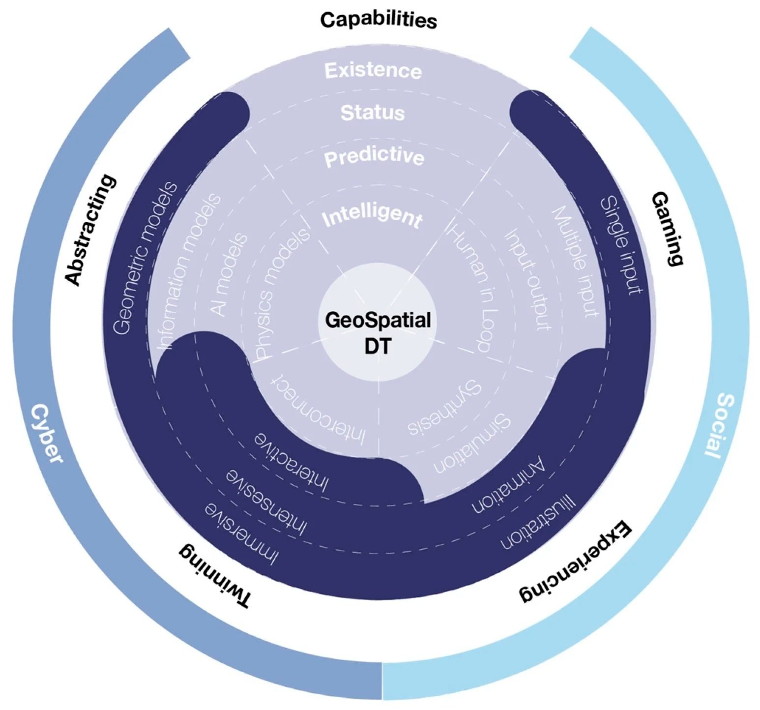
Figure 9. Geospatial Digital Twin frameworks customized for the JaxTwin project.
Social – Experiencing: Data Animation of Flooding Scenarios
Through highly realistic simulations of flood impacts, the system enables users to perceive and interpret the dynamics of the built and natural environments intuitively (Figure 12). The experiential aspect of a GDT is valuable for understanding how a space changes over time, rather than just analyzing the data.
Figure 10. LiDAR point cloud transformed into discrete 3D buildings.
The GDT goes beyond just modeling numbers and starts engaging humans and their way of thinking. To borrow an analogy, to understand a river, a hydrologist needs to analyze it through data, and a swimmer needs to directly experience its currents. Likewise, JaxTwin bridges analytical and experiential ways of knowing through its dynamic environment that reflects real life.
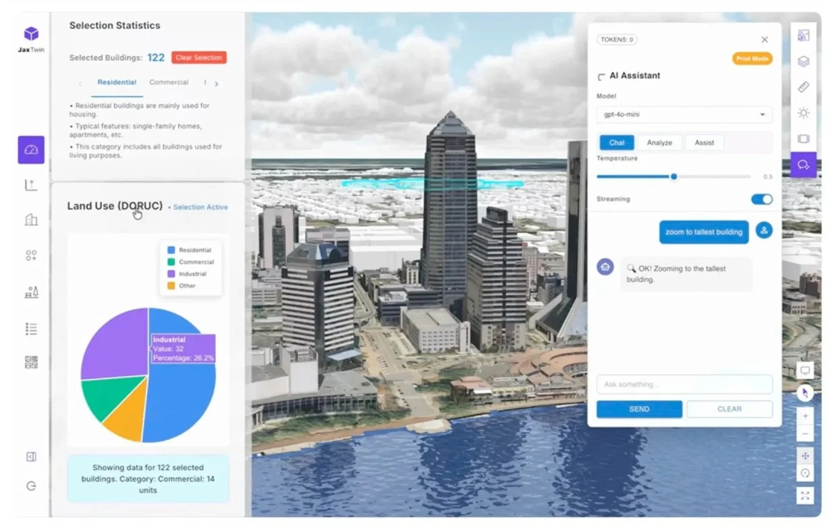
Figure 11. Graphical user interface of JaxTwin.
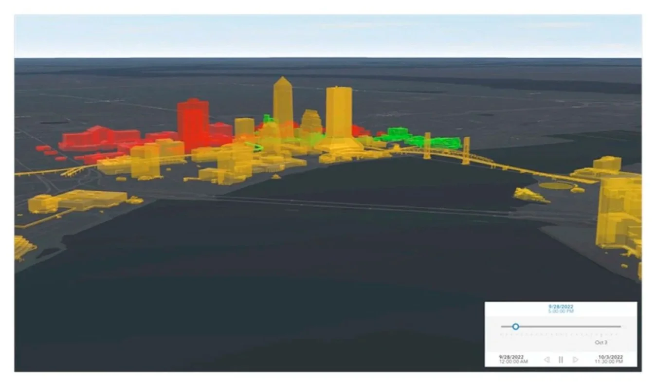
Figure 12. Color-coded buildings in JaxTwin showing the flood depth at each building during the hurricane.
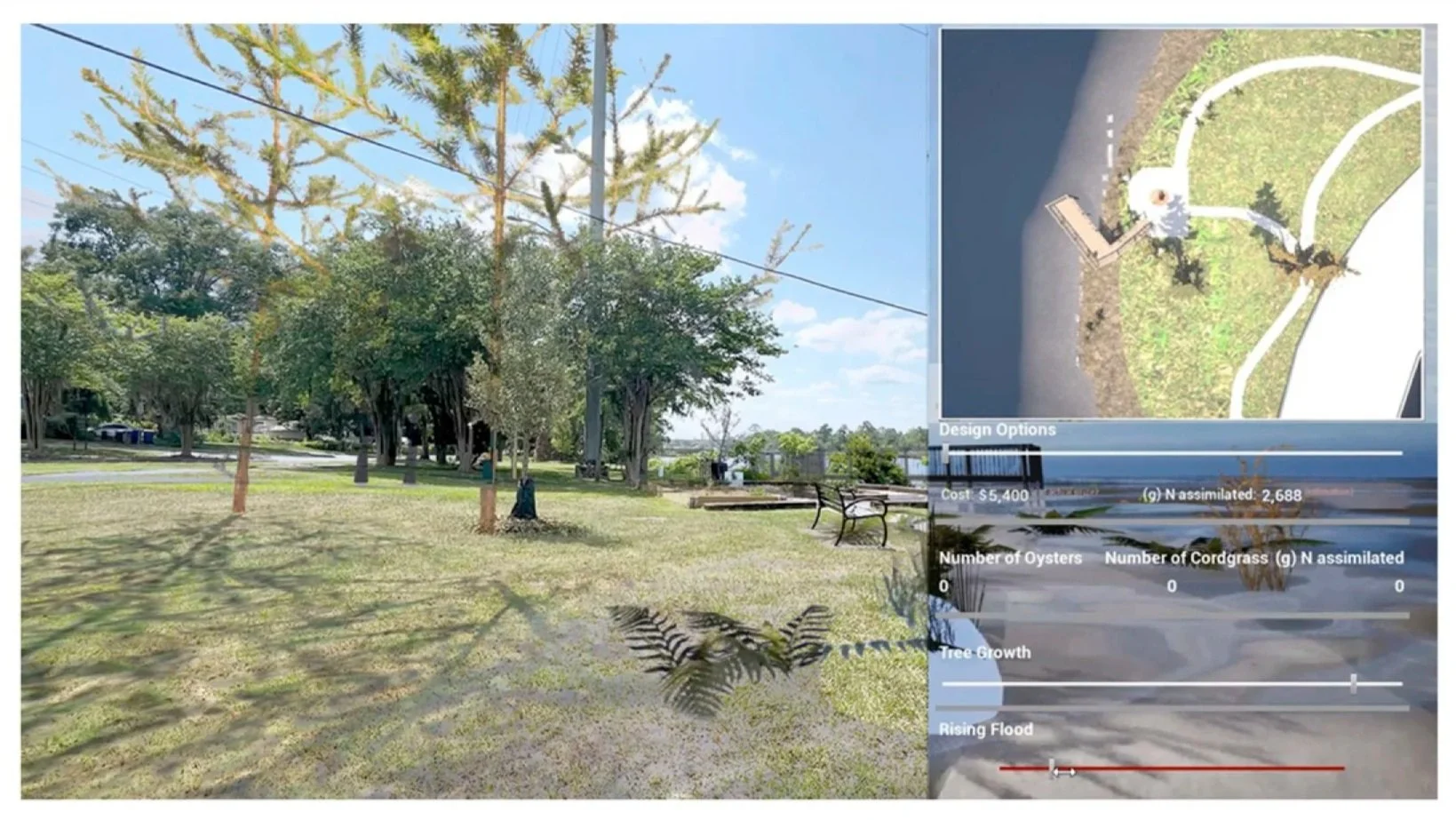
Social – Gaming: Interdisciplinary Co-Design of VR Experience
The JaxTwin VR experience allows users to position and adjust oyster reef “castles” and vegetation, while the system calculates nitrogen and carbon assimilation in real time. Changes to the design immediately update the environmental impact of the design through levels of assimilation. The ability to control, test, and tweak the design under various shoreline conditions provides both a visual understanding and numerical data for non-experts and experts (Figure 13).
The project provides visuals that help people understand abstract and complex systems, creating transparency that lets the community, planners, and specialists understand each other and work together more efficiently.
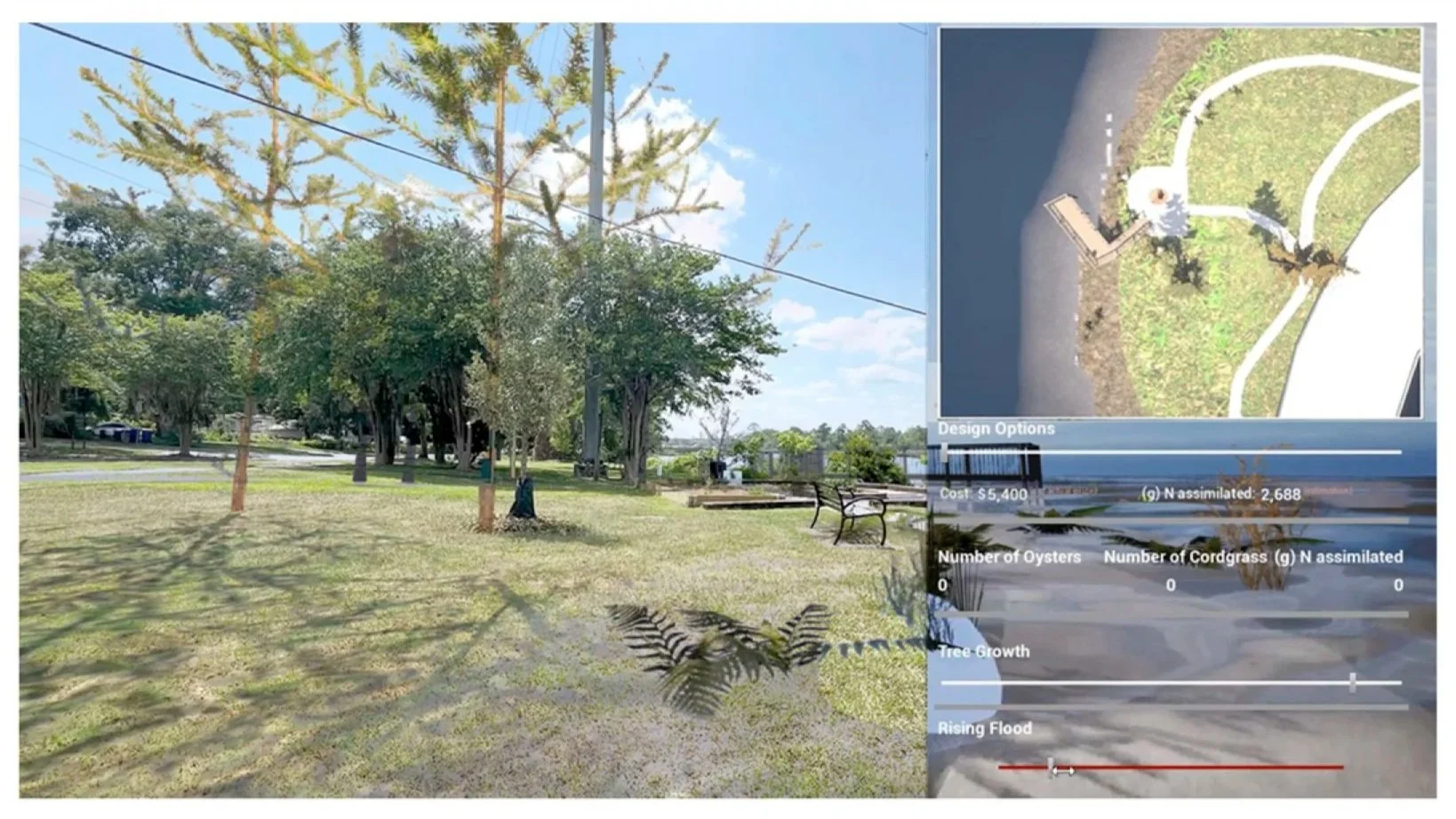
Figure 13. Augmented reality (AR) interface with models loaded and overlayed over the park, flooding conditions modeled and overlayed with the ground, as well as tree growth adjusted. The minimap, sliders, and environmental outputs are located on the right side of the interface.
Discussion and Conclusion
Unlike standalone computational urban models, the GDT framework unifies social and technical features into a single framework that integrates these models as modules, bridging technical modeling with participatory processes across four spectrums.
The development of the theory emphasizes the need for protocols and structure that separate GDTs from traditional models. Harmonizing the data, interconnectivity, and intensity is essential to twinning. This model framework proposes a gaming approach to incorporate social context and human input into models.
The digital model and physical world should have a back-and-forth flow of data so the model updates in real time or even predicts changes. It provides decision-making tools tailored for non-experts to interact with a realistic virtual replica, facilitating policy processes regarding disaster response, urban planning, and facility management.
This framework keeps humans involved in the process to ensure that technology enhances, rather than replaces, the human element in urban planning and design.
Campustwin and JaxTwin apply these ideas to make decision-making a bigger part of these complex systems. Deeper feedback loops, where public input becomes part of the system to reshape the technical architecture, are a direction for future work. What we have is a proof of concept of a flexible framework that is not just a comparison to existing planning approaches.
Looking into decision quality or planning outcomes to validate the systems is an important direction for future research.
The credibility of GDTs in making decisions depends on how responsibly the data is treated, and our framework suggests strategies for this. Establishing formal governance protocols and standardizing ways to audit mechanisms will be necessary as GDTs become more prevalent in institutions and governments.
We acknowledge that creating a full circle of feedback that influences architecture is still in development, so deepening the connection between stakeholder knowledge and computational modeling will be essential.
Furthermore, current implementations do not fully address who defines the problems, selects parameters, and shapes solutions. As GDTs advance to involve more human input, future models can incorporate mechanisms to ensure the inclusion of diverse stakeholder groups.
Gallery