Enhancing Demand-Oriented Regionalization with Agentic AI and Local Heterogeneous Data for Adaptation Planning
In collaboration with Mobina Noorani, Shangde Gao, and Changjie Chen
1 Introduction
Today’s urban governing relies on planning units to design and implement policies for growth, management, and adaptation to socioeconomic and environmental changes. These frameworks of space allow planners to evaluate the distribution of resources, assess policy impacts, and ensure policy coherence on multiple scales. The planning units also provide common connections to facilitate participation and open decision making.
Existing planning units, such as administrative boundaries or census divisions, were designed for specific purposes and were often misaligned with urban government demands. For example, census units can reflect population-based data collection rather than hazard exposure or social vulnerability. The rigidity of these units, combined with limited local knowledge and specific data, limits the ability of planners to design regions tailored to specific disaster or adaptation objectives. Data-driven regionalization can offer a promising solution by integrating multilayered local data to produce similar continuous regions aligned with planning objectives. Unlike conventional units, data-driven regionalization has the potential to capture social, environmental and physical heterogeneity. However, implementing such regionalizations remains challenging due to the complexity of constraints, the need for interpretability, and the iterative nature of planning decisions.
By combining generative reasoning, constraint-aware guidance, and human-in-the-loop interaction, agentic AI can help planners develop divisions of space and iteratively refine generated regions. Building on this opportunity, we present an agentic AI based planning support system that implements a data-driven demand-oriented regionalization framework, RepSC-SOM (Representative-initialized Spatially Constrained Self-Organizing Map). The framework extends traditional SOM with representative-based initialization, adaptive geographic filtering, and region-growing refinement, while AI agents can assist users in suggesting input features, guiding constraints of space, and supporting interactive exploration. The platform can enhance flexibility, transparency, and adaptability in planning space, supporting precise resource allocation, prioritization of interventions, and coordinated responses in disaster risk management and climate adaptation.
2 Methods
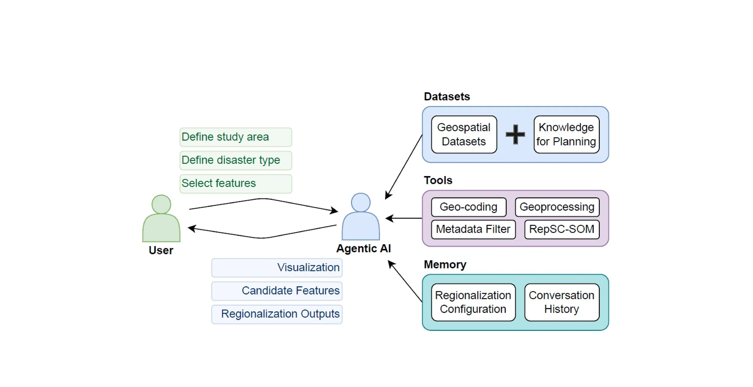
2.1 Architecture of Agentic AI-Enhanced Planning Support System for Regionalization
We present a central planning agent to orchestrate the regionalization workflow (Fig. 1). Users engage with the platform through a conversational interface, specifying their study area and hazard of interest. The AI interprets these inputs and autonomously geographically encodes the user’s location, selects and configures relevant geographic datasets, and visualizes the features of the space as interactive map layers. The agent further summarizes the characteristics of the data set and obtains user preferences for feature selection and the number of regions to generate. Once the user’s preferences are set, the agent calls the RepSC-SOM regionalization algorithm, integrating the resulting spatial divisions into the map interface for user exploration. This seamless experience enables non-technical users to perform advanced spatial analyses and explore alternative scenarios, lowering barriers to the application of machine learning in geographic decision support of space.
2.2 Overview of RepSC-SOM Framework for Demand-Oriented Data-Driven Regionalization
In the RepSC-SOM framework, regionalization is carried out through a SOM-based three-step Embedding-Clustering-Refining process. The outputs at each step are transparent and interpretable, enabling users to adjust the configurations and intervene in the process as needed.
In the Embedding step, an auto encoder finds hidden patterns and relationships in the data defined by the user-input features. Meanwhile, the SOM is initialized according to the geographic rules. The Clustering step then maps cells into clusters. Each location is assigned to the nearby group with the most similar data features. As this process repeats, the groups gradually adjust and become more organized, creating initial regions with similar characteristics
Finally, in the Refining step, the SOM output constrained by space is processed to improve the compactness and reduce fragments. The partitioned initial regions are merged based on the number of regions the user chooses, their similarity of features, and constraints. The output of the Refining step is the regionalization result and is then presented to the users.

Figure 1: Architecture of the Agentic AI-enhanced planning support system for regionalization.
3 Demonstration of the Proposed Agentic AI-Enhanced Planning Support System
We demonstrate the capabilities of our proposed system through a case study in an urban area facing diverse climate and disaster risks. The demonstration highlights how the proposed platform supports planners in designing targeted intervention strategies to address hazard-specific vulnerabilities by integrating local data, identifying priority areas, and refining regional boundaries.
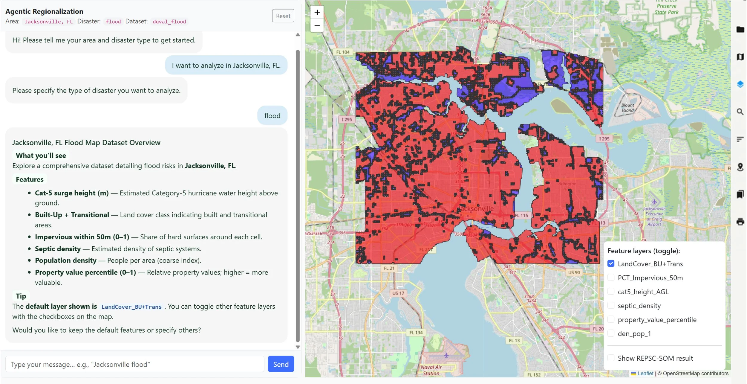
Figure 2: Screenshot of the proposed platform showing input features for regionalization based on user-specified study area and disaster type.
Interactive Selection of Input Features Based on Study Area and Disaster Type. Users can begin by specifying their study area (Jacksonville, FL, in this case) and the type of disaster (flooding, in this case) through the platform interface. Based on the selected region and the disaster type, the system selects and presents the candidate features for regionalization, such as socioeconomic indicators, environmental conditions, and the infrastructure vulnerability (Fig. 2).
Regionalization Using the RepSC-SOM Framework. After selecting the suggested features, users specify the desired number of regions. The system then runs the RepSC-SOM regionalization and presents the results on an interactive map (Fig. 3), where users can interpret and evaluate the output.
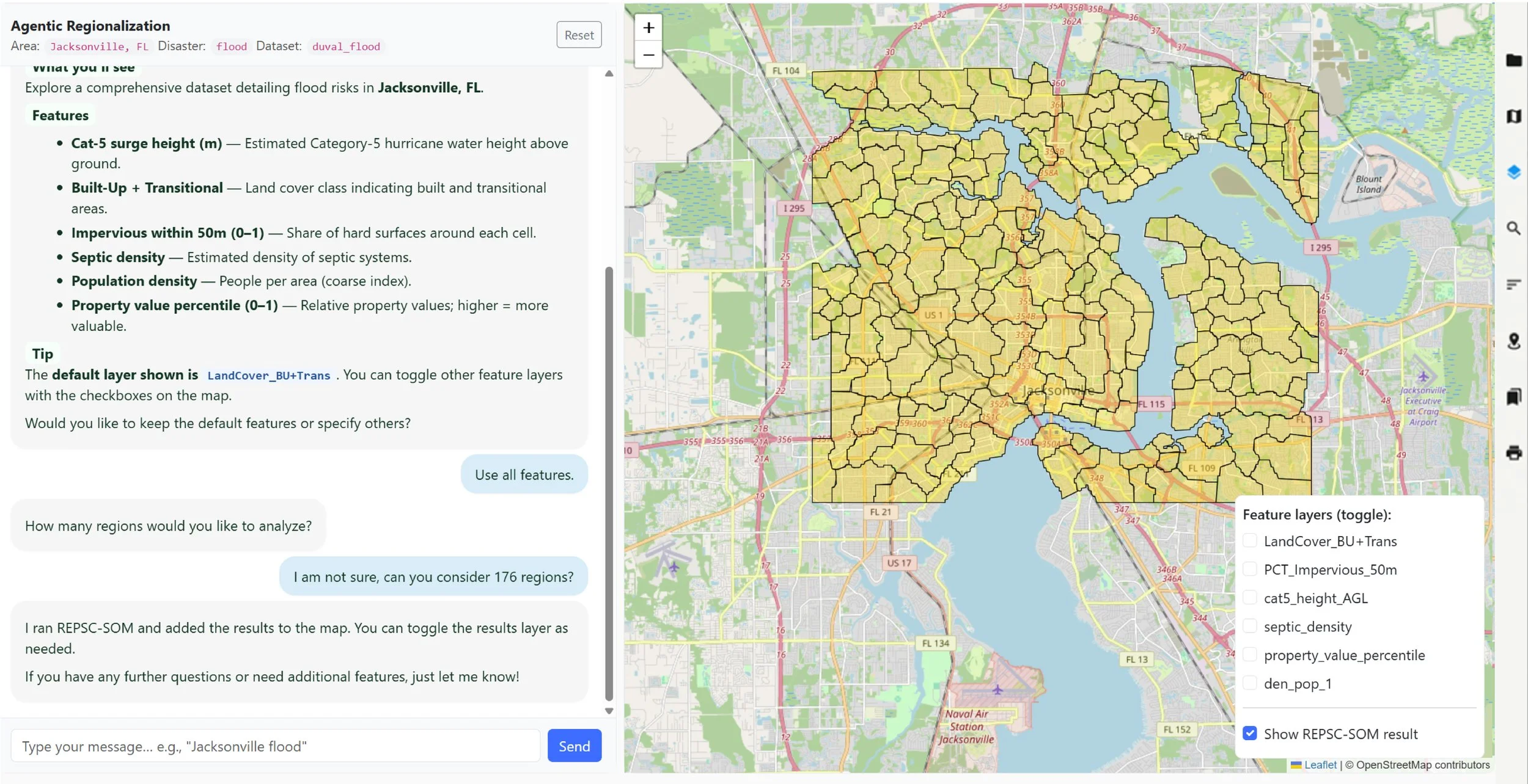
Figure 3: Screenshot of the proposed platform displaying the regionalization output.
4 Conclusion
Our study demonstrates that a planning support system with agentic AI can support urban planners without a coding background to generate planning units that better capture local disaster risks than conventional units. Its interactive, human-in-the-loop design allows regions to flexibly respond to dynamic hazard patterns and evolving urban conditions, supporting resilient and equitable adaptation strategies.
Gallery